
Keona Road in McDowall
Consultation has concluded
Updated April 2021
Consultation on Keona Road in McDowall has now closed. Thank you to everyone who provided feedback. The project team will consider all feedback received, and provide an update to the community when more information is available.
Brisbane City Council is pleased to announce that in response to concerns raised by the local community about motorist and pedestrian safety along Keona Road, funding was allocated to undertake community consultation in the Suburban Corridor Modernisation budget.
Council is now inviting feedback from local residents on potential traffic and safety improvements you would like to see along Keona Road. To assist you Council has listed nine potential traffic and safety improvement ideas for your consideration. You can view all of the ideas here before completing the feedback survey below. Council is also interested to hear additional feedback or suggestions you may have about traffic concerns along Keona Road. You can provide your feedback via the interactive map.
Some suggestions may require consultation with the Department of Transport and Main Roads.
Keona Road is classified as a Neighbourhood Road in Brisbane City Plan 2014. Brisbane City Plan 2014 (City Plan) guides future development in Brisbane. It guides how land in Brisbane can be used and developed and sets out the plan that ensures appropriate infrastructure to support growth.
Your feedback will help inform decision making and future planning for further investigations and the design of traffic and safety improvements.
This consultation period will be open for four weeks until midnight Friday 9 April 2021.
-
Idea 1 - Keona Road / Old Northern Road – Intersection Improvement
Consultation has concludedSplitter island with pedestrian slot and associated ‘No Stopping conditions’ to improve pedestrian connectivity, safety and visibility for all road users.
NOTE: ‘No Stopping conditions’ refers to yellow line markings or signs
-
Idea 2 - Various intersections along Keona Road – Pedestrian access and visibility improvements
Consultation has concluded- Kerb ramp realignment and associated ‘No Stopping conditions’ at intersections to improve pedestrian connectivity along the road and visibility for all road users.
- Installation of Give Way signs and line markings to improve driving paths and visibility for all road users.
NOTE: ‘No Stopping conditions’ refers to yellow line markings or signs
-
Idea 3 - Keona Road at Trouts Road – Intersection improvement
Consultation has concluded- Removal of left turn lane and upgrading the pedestrian crossing connectivity with associated ‘No Stopping conditions’ to improve visibility and safety for all road users.
NOTE: ‘No Stopping conditions’ refers to yellow line markings or signs
- Removal of left turn lane and upgrading the pedestrian crossing connectivity with associated ‘No Stopping conditions’ to improve visibility and safety for all road users.
-
Idea 4 - Keona Road between Old Northern Road and Trouts Road – No Stopping conditions
Consultation has concluded- Installation of ‘No Stopping conditions’ along Keona Road in locations where the road narrows, to improve visibility and safety for all road users.
To assist with planning, please indicate on the interactive map the exact location of where you would prefer ‘No Stopping conditions’.
NOTE 1: ‘No Stopping conditions’ refers to yellow line markings or signs
NOTE 2: Road widening with associated kerb and channel can be considered. However, it is important that it is considered alongside adjacent property redevelopment. This will ensure the extent of any road widening can take into account the nature of future property development andContinue reading
-
Idea 5 - Keona Road between Old Northern Road and Trouts Road – Lane line markings
Consultation has concluded- A review of line marking along the road to ensure they are fit-for-purpose.
NOTE: Due to the limited road width along the corridor, street parking may need to be removed to provide lane line markings.
-
Idea 6 - Keona Road between Old Northern Road and Trouts Road – Footpaths
Consultation has concluded- The construction of missing footpath links.
To assist with planning, please indicate on the interactive map the exact location of where you would prefer footpaths.
NOTE: Footpath construction may need to be considered alongside adjacent property redevelopment. This will ensure this takes into account the nature of future property development and ultimate footpath alignments.
-
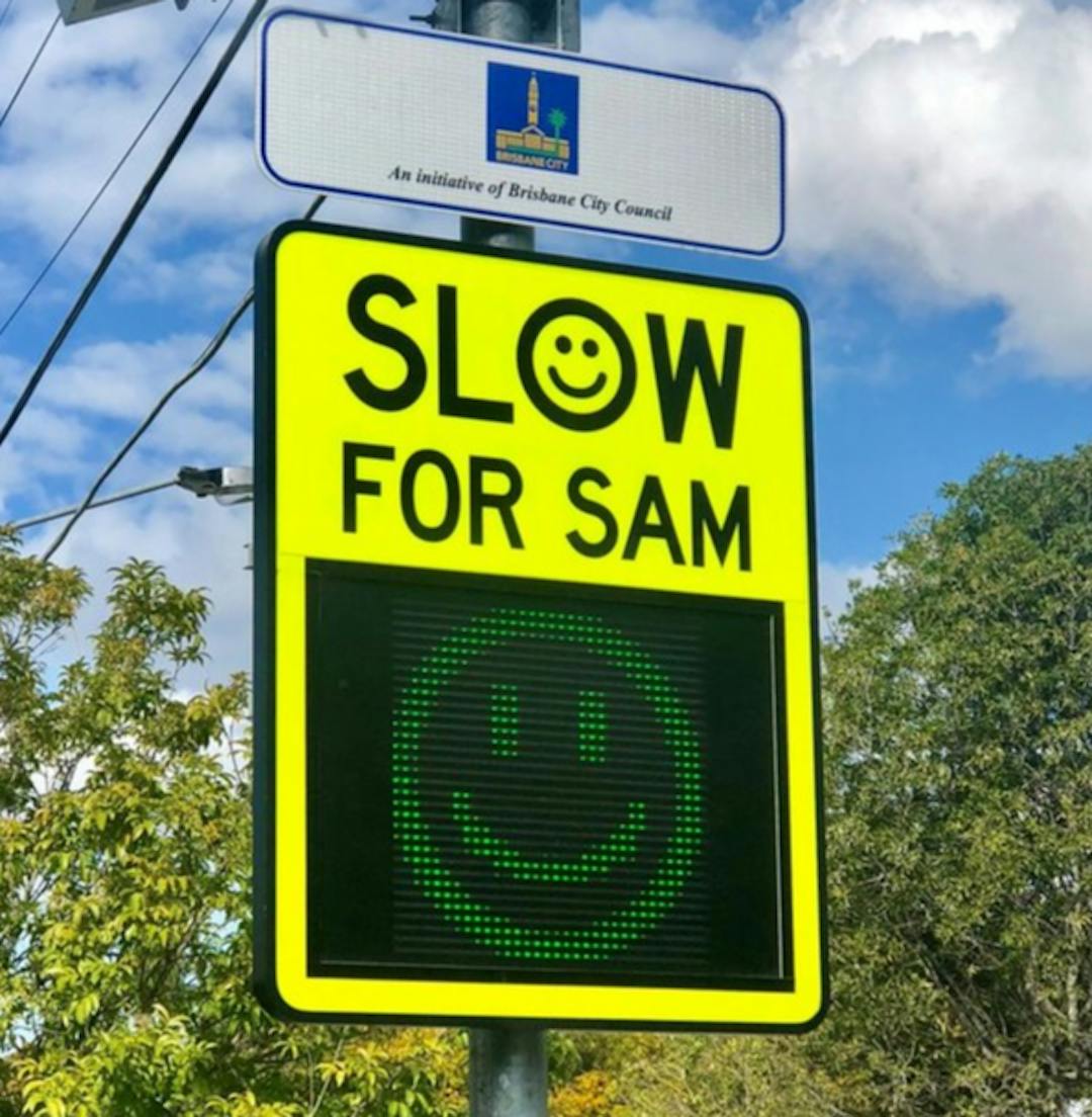
Idea 7 - Keona Road between Old Northern Road and Trouts Road – Speed Awareness Monitors (SAMs)
Consultation has concluded- The installation of SAM signs on Keona Road to improve motorist awareness of the speed limit on Keona Road. More information about SAM signs is available on Council’s website www.brisbane.qld.gov.au by searching for ‘Speed Awareness Monitors’.
To assist with planning, please indicate on the interactive map the exact location of where you would prefer a SAM sign.
NOTE: SAM signs are not a permanent fixture and are rotated between various locations in the McDowall Ward. SAM signs are not suitable for all locations within our road network. If a location is supported, Council undertakes a site assessment to determine if the location is suitable for a speed awareness monitor.
-
Idea 8 - Keona Road between Old Northern Road and Trouts Road – LED road signs
Consultation has concluded- The highly visible LED road signs are designed to alert drivers of an upcoming intersection or traffic hazard, and to reduce their speed if they are travelling above the speed threshold that is pre-determined for that location.
- The signs are vehicle activated signs meaning they are triggered by an approaching vehicle. The LEDs on the signs are inactive (unlit) by default and as a vehicle approaches, the speed is detected by the sign’s radar.
- The speed threshold at which the sign is activated is not the speed limit for that location, rather, one that is pre-determined as a safe speed to approach the upcoming intersection or traffic hazard.
- More information about LED road signs is available on Council’s website www.brisbane.qld.gov.au by searching for ‘LED road signs’.
-
Idea 9 - Keona Road between Old Northern Road and Trouts Road – Local Area Traffic Management
Consultation has concluded- The construction of devices such as speed platforms, traffic islands and kerb buildouts along Keona Road to:
- Provide a safe environment for pedestrians and cyclists.
- Discourage non-local traffic, commonly known as ‘rat running’ in neighbourhood streets.
- Moderate vehicle speeds.


